Mansala Gold Project
The Mansala Project encompasses an area of 48km2 to the south of Alahiné.
Systematic exploration of the Mansala Licence commenced in December 2020 with an extensive program of reconnaissance soil geochemistry.
The results of the survey confirmed that in summary, 5.0km2 or 10.4% of the area surveyed reported Au values in excess of 40ppb Au. Of particular interest are gold abundances which are illustrated in the figure 1. A total of 11 samples returned Au assays in excess of 1,000ppb (1 g/t) Au, and include values of 93.98 g/t, 6.03 g/t, 5.85 g/t, 2.91 g/t, 2.38 g/t and 1.10 g/t which are plotted in figure 1.
The distribution of these high values appears to mirror topography, which itself is controlled by outcropping lateritic and ferricrete knobs and ridges. The possibility exists that these topographic highs are the product of topographic inversion, where lateritic fill in ancient river valleys becomes cemented with iron oxides and are strongly resistant to erosion. Thus, with ongoing erosion, ancient river valleys might now be expressed as hills and ridges of this resistant material. Potentially, such inferred ancient river valleys may host either hard rock or deep lead gold mineralisation. Artisanal miners have exploited gold shedding from present day topographic highs but have not addressed potential deeper mineralisation within or beneath the hills and ridges.
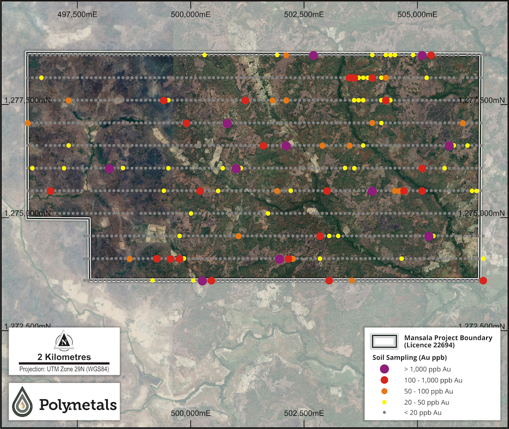
Figure 1: Mansala Soil Program. Gold (Au) assays superimposed on satellite imagery.
Also, of interest in the NE Quadrant of the Mansala Licence is an area of elevated topography. This area is geochemically prominent, with anomalous concentrations of Au, Ag, As, Mo, Sb, Fe, Cr, Ti and P present in soils. The significance of these responses is not known but may be indicative of mineralisation at depth. Numerous artisanal workings in this area lend credence to this possibility.
The Mansala soil sampling program successfully identified 6 potential targets and areas of interest.
A rock chip sampling program was undertaken in H1 2022 to confirm the nature and gold content of material extracted by artisanal miners in the NE Quadrant. A total of 103 samples were collected from the walls of abandoned 1m x 1m artisanal mining shafts and directly from active artisanal workings.

Figure 2: Mansala artisanal pit sampling. Location of area sampled is shown within inset map of the Mansala licence. White rectangles denote Au-anomalous soils tested by auger drilling.
A number of high-grade assays have been returned, including 16.70 g/t Au, 8.35 g/t Au, 5.74 g/t Au and 5.48 g/t Au. The strike extent of the mineralised zone is approximately 600m and is open to the north and south.
An auger drilling program was completed at Mansala in Q2 2022, with a total of 6,123m drilled comprising 799 holes at an average depth of 7m. The program was completed on a 100m x 50m drill pattern over six delineated areas.
The objective of the auger program was to test gold-in-soil anomalies supported by coincident pathfinder elements (As, Ag, Mo, Sb, W and Te). Strong gold anomalies (>1000ppb) without supporting pathfinder elements will be investigated further before drill-testing. The best drill results from assays received include 3m @ 4.57 g/t Au, 3m @ 3.26 g/t Au and 1m @ 2.50 g/t Au.
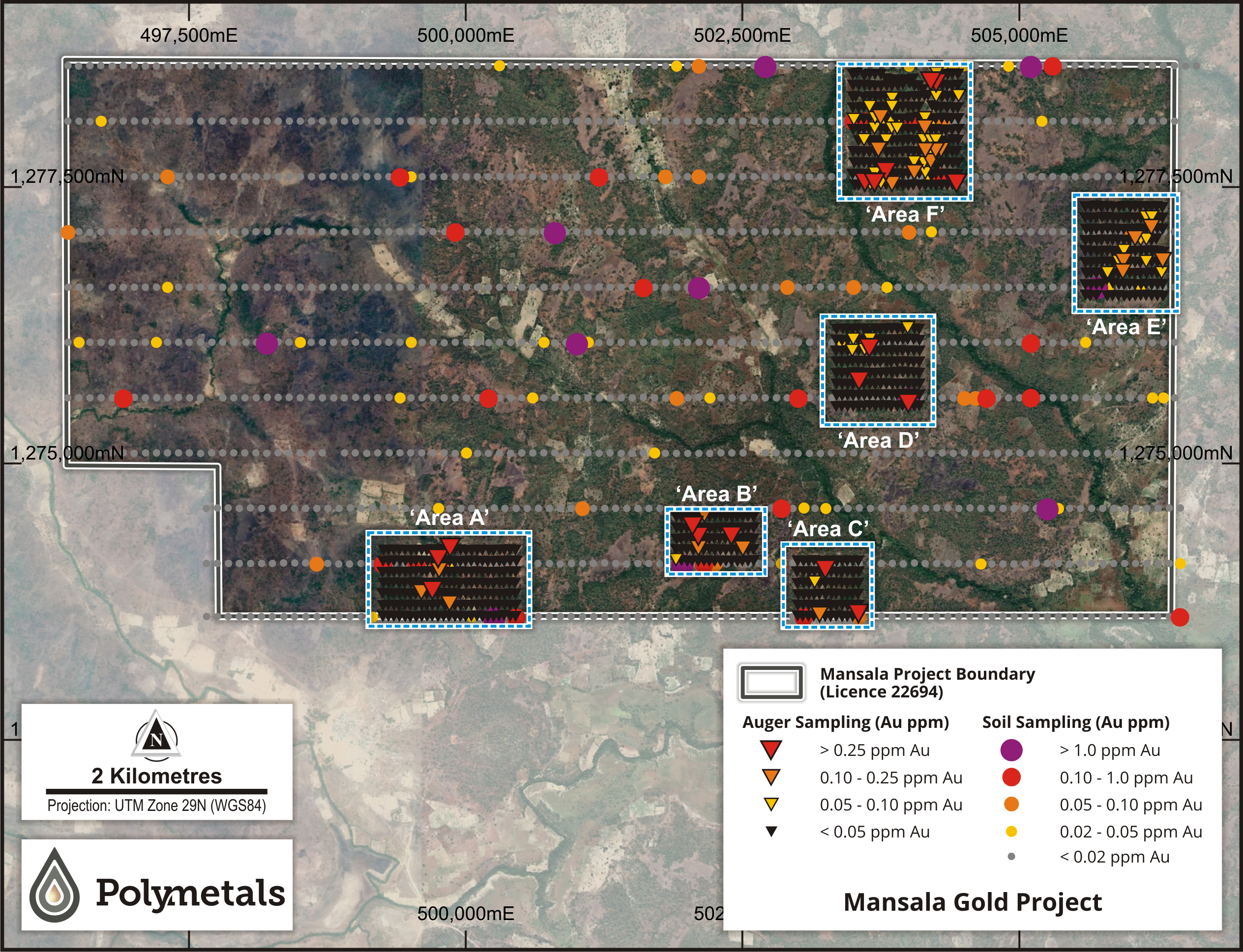
Figure 3: Mansala auger gold results overlaid on thematically mapped gold in soil values and satellite imagery.
Best auger drill intervals taken at end of hole within Area F include 1m @ 1.09 g/t Au and 1m @ 0.34 g/t Au. Interpretation of auger assays received suggest that Area F is very prospective and likely to have multiple mineralised trends. As a priority, auger assays revealed an additional >300m long eastern mineralised auger trend (see Figure 2), near parallel to the mineralised pit sampling trend and likely to merge in the south.
All single station anomalies identified by the auger program are important and warrant further investigation. Mapping and sampling of priority targets within each of the defined areas will confirm the appropriate follow up method.
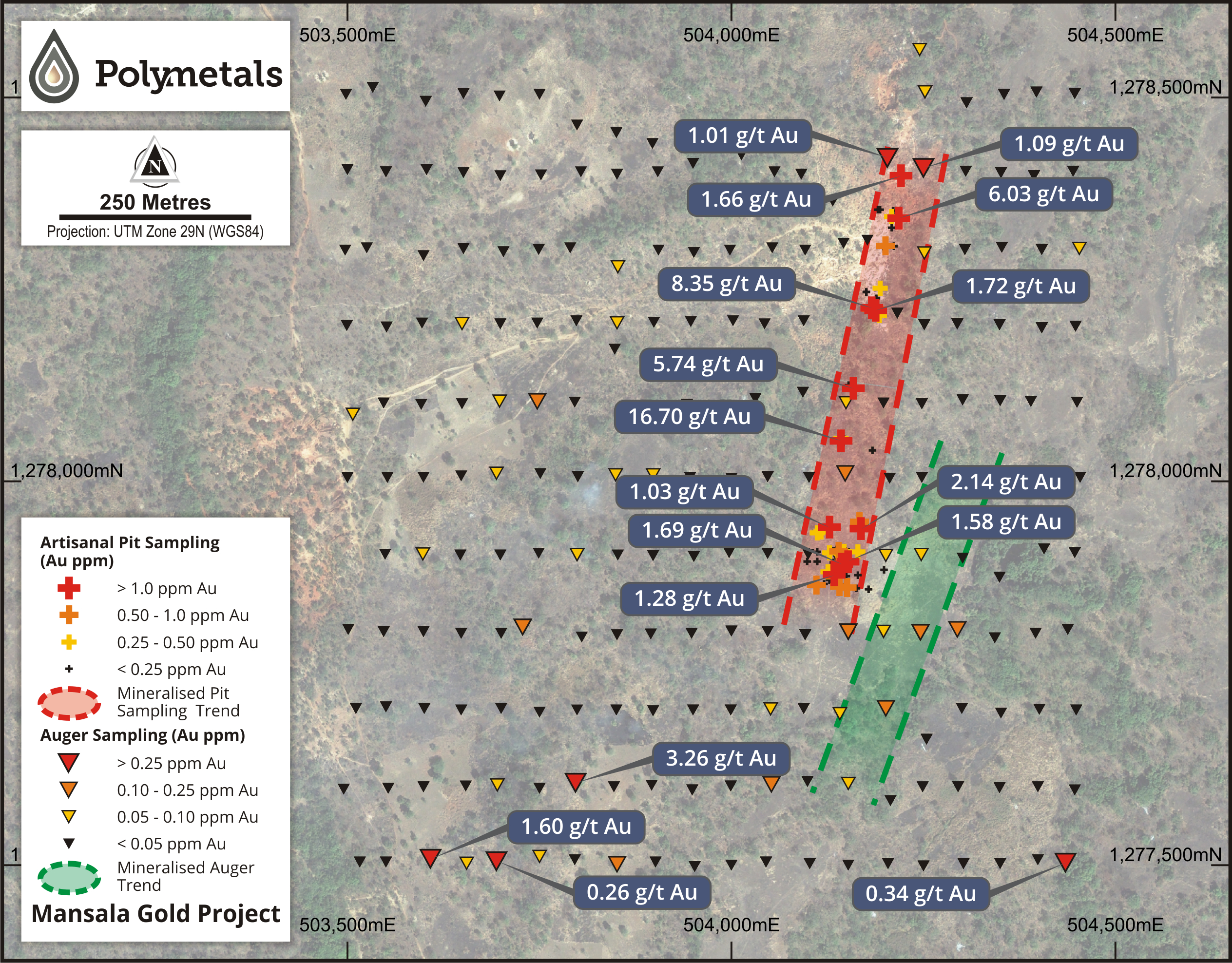
Figure 4: Mansala Area F auger drilling illustrating best intervals intersected, including pit sampling. Satellite imagery displays artisanal workings at the north end of the mineralised zone.
Mansala Airborne Magnetic Survey
The airborne magnetic survey at Mansala was conducted by AeroPhysX in June 2022 on 100m-line spacings. The objective of the approximately 500-line km survey was to provide detailed data to determine the structural controls of mineralisation and information on the nature and disposition of host rocks currently obscured by lateritic cover.
The geophysical data has been processed and an initial geological interpretation and target generation program has been carried out with eight (8) high order geophysical targets identified. Project-level aeromagnetic and interpreted geological maps are provided in Figures 1-3. Survey details are provided in Appendix 1.
Images of processed aeromagnetic data show NW – NNW and NE – NNE magnetic lineaments pattern, as well as lithological and structural features that may have controlled the localisation of the known gold mineralisation. Another key structural feature identified is the intense folding with axial planes along NNW and NNE directions that may influence mineralisation.
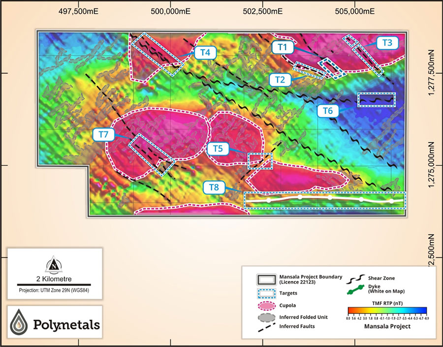
Figure 5: Mansala Gold Project – Aeromagnetic map showing Cupolas and Major structural features – faults, lineaments, shear zones and high-priority geophysical targets.