Alahiné Gold Project
Alahiné Gold Project encompasses an area of 64km2 and displays intense shallow artisanal mining throughout the licence.
Initial soil programs in 2018 and 2019 were successful in delineating broad zones of gold anomalism along the eastern side of the licence and a significant number of single and multiple-station highly anomalous sites across the licence.
The objective of Polymetals’ efforts at Alahiné is to discover “Siguiri-style” mineralisation akin to the AngloGold Ashanti (ASX:AGG, NYSE:AU) >10Moz Siguiri Gold Mine, located 37km west of the Alahiné licence.
In total, the Company has completed 751 power auger holes (totalling 8,619m), 94 air core (AC) holes (totalling 6,840m) and 78 reverse circulation (RC) holes (totalling 6,865m).
The Company recently completed the Alahiné Phase 3 drilling program,
The Phase 3 drilling program at the Alahiné Gold Project focussed on confirming the strike continuity and down-dip extent of mineralised intersections reported from previous drilling programs. In addition, the program aimed to extend mineralisation to the south, along strike of the known mineralised areas.
Drilling has also successfully demonstrated continuity of mineralisation over a strike length of 1700m.
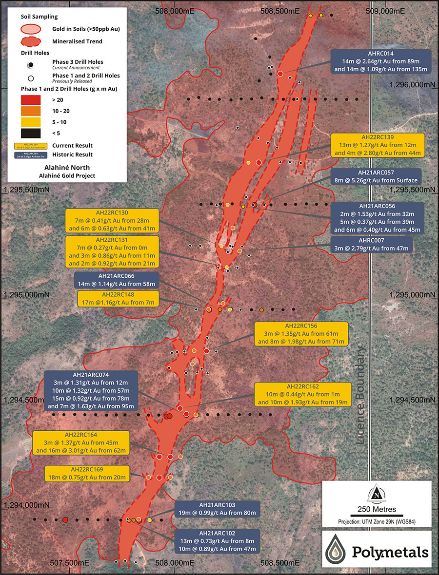
Figure 1: Alahiné North – Plan view of drill holes and prominent NNE mineralised zone.
Gold is associated with quartz-carbonate-pyrite veins and veinlets within zones of moderately silica-carbonate altered Birimian metasedimentary rocks. In addition to the quartz vein hosted gold, broad intervals of felsic intrusive-hosted narrow quartz veins are mineralised with the gold associated with fine grained disseminated pyrite. Mineralisation appears to boudinage (swell and pinch) along strike and remain open at depth in the southern half of the mineralised zone.
The drilling intersected mineralisation on infill drill traverses along strike, down-dip and up-dip of follow-up previous drill holes.
Section 1,294,250N (Figure 2) was drilled to test continuity along strike between two previously drilled gold mineralised sections spaced 500m apart. Results show continuity of mineralisation along strike and down dip with end of hole mineralisation in AH22RC166, indicating the mineralisation is open at depth to a vertical distance of +100m.
The key intercepts within section 1,294,250N are as follows:
- AH22RC164
- 3m @1.37 g/t Au from 45m; and
- 16m @ 3.01 g/t Au from 62m; and
- AH22RC165
- 4m @ 10.62 g/t Au from 8m;
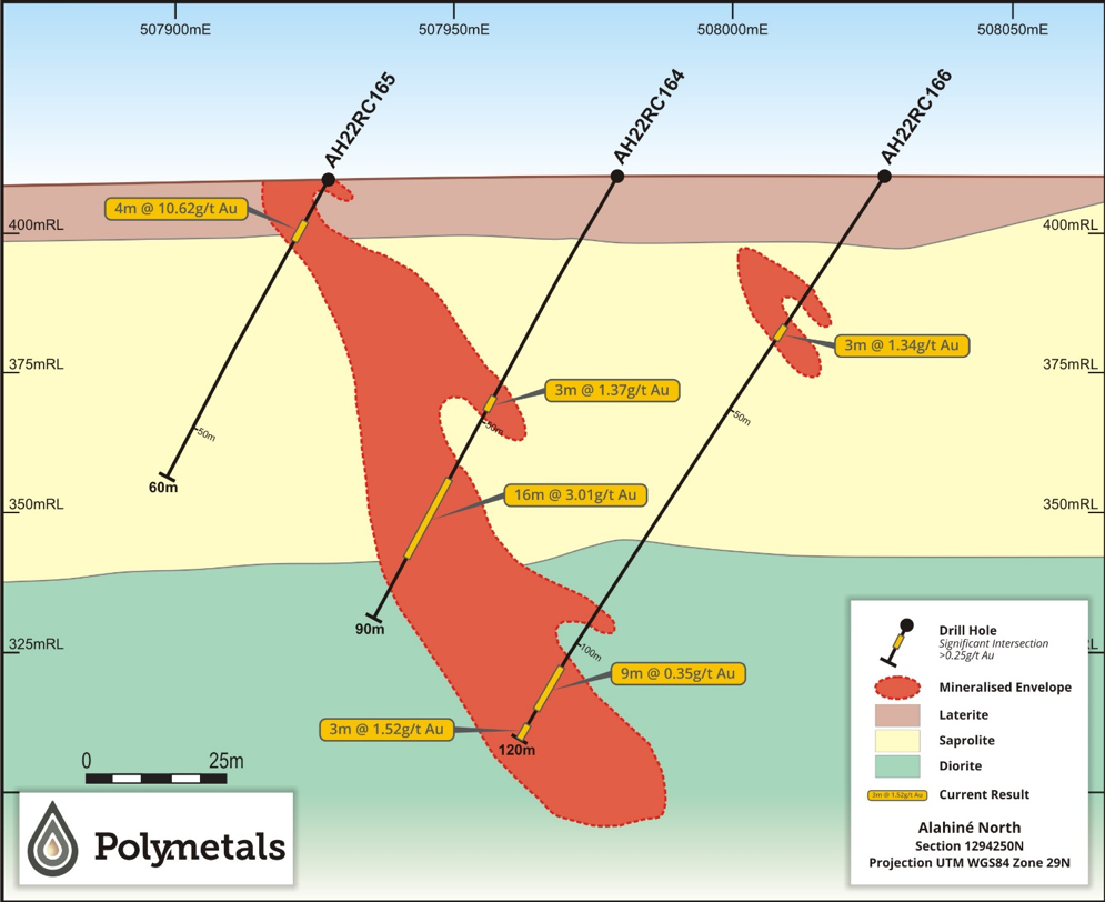
Figure 2: Section 1294250N – Infill drilling from previous drilling campaigns delivering 16m @ 3.01 g/t Au.
Alahiné Airborne Magnetic Survey
The airborne magnetic survey at Alahiné was conducted by AeroPhysX in May 2022 on 100m-line spacings. The objective of the 700-line km survey was to provide detailed data to determine the structural controls of mineralisation and information on the nature and disposition of host rocks currently obscured by lateritic cover.
The geophysical data has been processed and an initial geological interpretation and target generation program has been carried out, illuminating at least ten (10) high order geophysical targets. Project-level aeromagnetic and interpreted geological maps are provided below.
Images of processed aeromagnetic data show magnetic lineaments, as well as lithological and structural features that may have controlled the localisation of the known gold mineralisation.
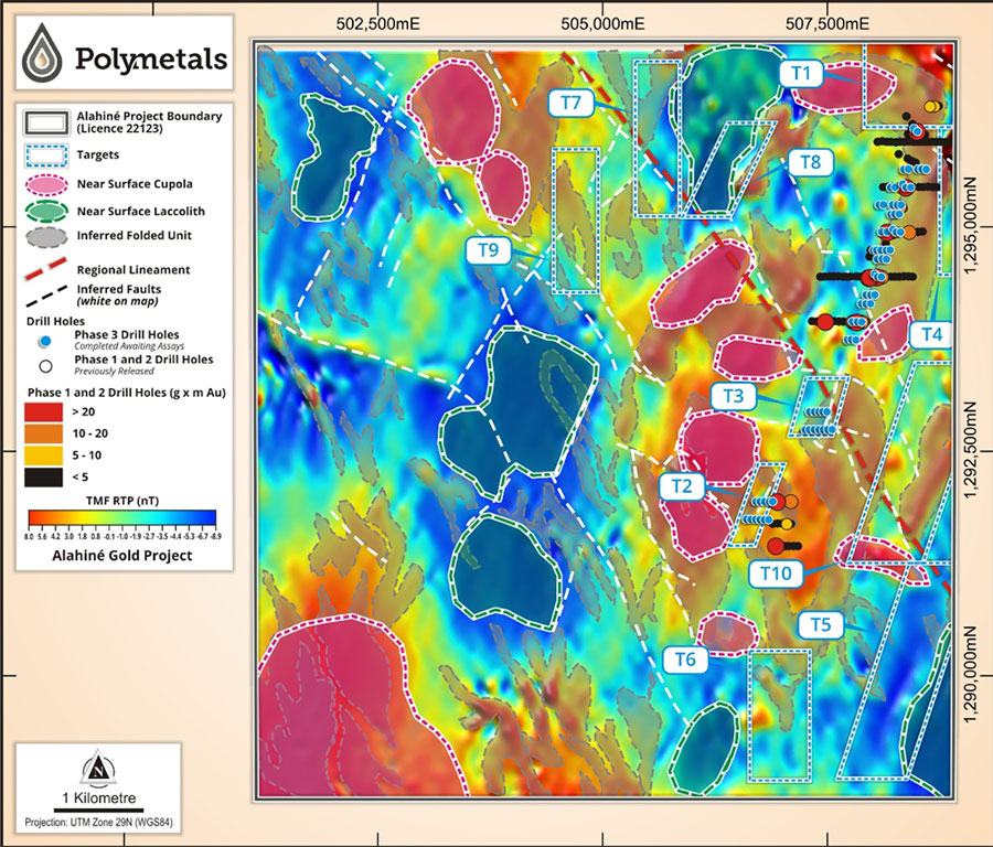
Figure 3: Alahiné Gold Project – Aeromagnetic map showing key faults, lineaments, major structural features and high-priority geophysical targets.